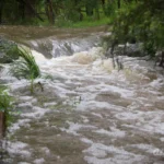
Salt Creek in Flood
Posted 9th January 2024
No comments
With an abundance of rain across much of Victoria, I decided to head out to see the impact of the heavy falls on my local waterway.
Powering up the SECV
Posted 21st October 2022
No comments
Victorian Premier Daniel Andrews has announced that his government would revive the State Electricity Commission as an active energy market participant, if re-elected.

Very Windy
Posted 29th October 2021
No comments
We’ve had a windy 24 hours in Victoria and there has been widespread reports of damage across the state.
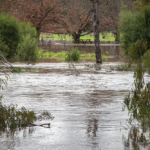
Yarra River in Flood
Posted 13th June 2021
1 comment
Following heavy rains across parts of Victoria in the past week, many of the state’s rivers are swollen.
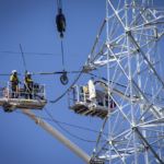
Relocating Transmission Lines in Watsonia
Posted 3rd February 2021
No comments
Today I chanced upon an impressive spectacle: the relocation of 220 kV electricity transmission lines in Watsonia.