Melbourne’s heat, graphed
Updated: Victorians have been sweltering these past few days. Let’s take a look at just how hot it has been.
As many Australian readers would be aware, it’s been awfully hot in Australia’s southern states these past few days. Following bushfires in Western Australia, the heat moved to South Australia and now Victoria.
Melbourne has been quite hot these past few days, especially last night where the temperature haven’t dropped below 27ºC. No wonder it has been a challenge sleeping! On Tuesday, the temperature peaked at 42.2ºC and Wednesday it peaked at 41.5ºC at 1:30pm with 14% relative humidity. A slightly cool change is now expected.
Here are the past two days’ temperatures, shown graphically:
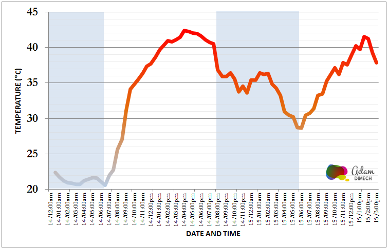
This certainly isn’t Melbourne’s hottest weather (I remember much worse) but it’s definitely been unpleasant. Thankfully I work in an air-conditioned facility and so have been sheltered from most of the heat.
Update: 16 January 2014
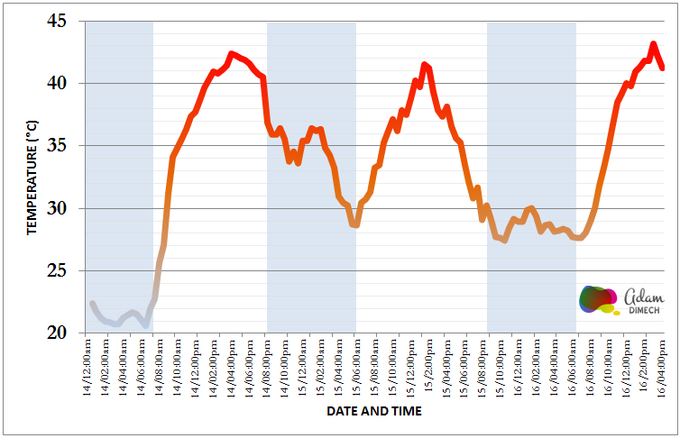
As the heat continues, here’s a chart of the day’s readings to 4pm from the Melbourne Weather Station. The day’s peak temperature was 43.2°C at 3pm this afternoon.
The heat has been so intense that fires have broken out in the Grampians and playing at the Australian Open has been halted.
Nevertheless, the Bureau of Meteorology has now issued a severe weather warning for Melbourne:
Severe thunderstorms are likely to produce damaging winds, heavy rainfall that may lead to flash flooding and large hailstones in the warning area over the next several hours. Locations which may be affected include Ballarat, Maryborough, Geelong, Melbourne, Traralgon and Bairnsdale.Bureau of Meteorology, 16 January 2014 at 3:14pm
Bureau of Meteorology, 16 January 2014 at 3:14pm
Unfortunately the storms will not lead to cool weather. The Bureau is forecasting a maximum temperature of 44°C tomorrow.
Update: 17 January 2014
According to The Age, this is the first time Melbourne has had four days in a row above 41°C since records began.
Across the State of Victoria, fires have been burning with one man dying in the Grampians fire. Unfortunately a number of fires look suspicious with Victoria Police Chief Commissioner Ken Lay claiming that police believe 12 of the 68 fires burning across the state were deliberately lit including suspicious fires in the northern suburb of Epping.
Here’s a graph of temperature measurements from the Melbourne Weather Station since the heatwave started until 5:00pm on 17 January 2014.
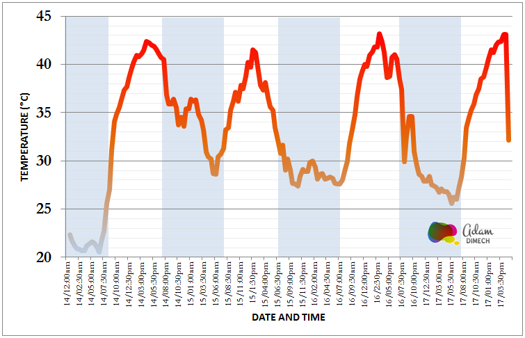
A cool change is expected very soon. The temperature has already dropped from a peak of 43.1°C at 4:30pm to 32.1°C in just half an hour.
Comments
4 responses to “Melbourne’s heat, graphed”
Indeed it is very hot. Maybe it has been hotter, but this heat is being sustained over several days and very high temperatures continuing overnight.
For those with air conditioning, it is bearable, but it must be stifling without cooling.
Those tennis players are very strong —-and perhaps very foolish, providing entertainment for the public, even though they are well paid.
This weather is extreme… not explainable in terms of normal weather patterns (la nina etc.). Human induced climate change is happening right now.
I am not saying it hasn’t happened, but I don’t remember four days of the temperature being over 40 degrees.
“”Andrew”” You would have to be a 106 to remember the first such occasion which was 1 day longer a 5 day scorcher. “”Graham”” wonder what that 1908 record had to do with Man Made Global Warming, Man made Climate Change
The longest heatwave in Melbourne was in 1908, when there were five consecutive days over 40C.
When CO2 was under 300ppm, well below the ‘safe’ 350ppm. ???????? “O dear”
Despite the IPCC and many other climate scientists refusing to link ‘extreme weather’ to climate change, the Climate Council (Tim Flim Flan Flannery) and the ABC (So far left they are off the planet) are quite happy to do so as part of a co-ordinated scare campaign: